Task Design
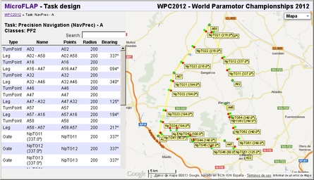
- Type (turn-point, gate, leg...)
- Name
- The list of points involved in the control
- Radius of influence
- Bearing when needed by the control's definition
- Zoom in/out using the mouse wheel.
- Click and drag to move the map.
- Use the map style selector to change between map, satellite or no map.
Clicking on any row will mark it as selected and the map be centered on the corresponding control.
You can return to previous pages:- Click on the championship name on the breadcrumbs line to return to the championship summary.
- Click on the MicroFLAP link to return to the main page (the championship list).
Representation of each control type
 |
 |
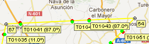 |
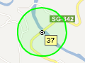
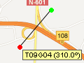
| Turn point | Gate | Leg |
|---|---|---|
| A dot labelled with its name and surrounded by a circumference of the defined radius. The sample image represents a turn point named 37 located on a bridge. |
A line connecting its two ends. The left end is represented in red and the right end in green, as in the standard navigation code. A label displays the gate's name and bearing. The sample image represents a gate centred on a crossroads that should be crossed in NW direction. |
A yellow line from the start turn point to the end turn point. Two parallel lines represent the left (red) and right (green) limits. The lines are only an approximation to the path that has to be flown. The sample image represents a leg from turn point 57 to turn point 54. Some gates can also be seen along the leg. |
Editing the task
If you have the required rights, you can edit the task using the options described in this section. Any changes made on a task which already has uploaded tracks will delete the results from the analysis and a reanalysis will have to be performed. This takes plenty of resources, so this is not automatically done on each change. Go back to the Championship Summary page to manually trigger the analysis when the design changes are done.
All coordinates are always referred to the WGS84 reference system.
Add Turn Point
A dialogue will be displayed with the following fields:
| Name | A short name that will be used to label the turn point. |
| Radius (m) | The radius given to the turn-point in metres. |
| Latitude | The latitude of the point in free format: -41.5, 41º 30' S, 41º 30' 0' S,... |
| Longitude | The longitude of the point in free format: -3.5, 3º 30' W, 3º 30' 0' W,... |
| Description | A description to help pilots find the point on the map and on the ground. |
Add Gate
A dialogue will be displayed with the following fields:
| Name | A short name that will be used to label the gate. |
| Radius (m) | The radius given to the gate in metres. The total width of the gate is twice the radius. |
| Bearing (º) | The expected crossing direction for the gate. |
| Latitude | The latitude of the point in free format: -41.5, 41º 30' S, 41º 30' 0' S,... |
| Longitude | The longitude of the point in free format: -3.5, 3º 30' W, 3º 30' 0' W,... |
| Description | An optional description to help finding the point on the map and on the ground. |
Add Leg
A dialogue will be displayed with the following fields:
| Name | An optional short name that will be used to label the leg. If this is omitted, a name will be automatically generated. |
| Radius (m) | The radius given to the leg in metres. The total width of the leg is twice the radius. |
| From | The turn point where the leg starts. |
| To | The turn point where the leg ends. |
Options on the selected control
- Find selected control: The selected control is centred on the map. This is equivalent to clicking on the control's row.
- Edit selected control: The selected control is edited using the corresponding dialogue. Current values are displayed and they can be modified except the name.
This can also be done by double-clicking on the corresponding table row. - Delete selected control: A confirmation dialogue is displayed. If confirmed, the selected control is deleted from the task.
Deleting the task
If the current task is not assigned to any class, the option "Delete this task" is displayed. Clicking on it a confirmation dialogue will be displayed. If confirmed, the task will be deleted.